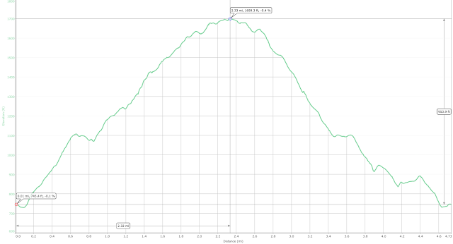
Maps, Elevations & Summary
Route to Summit: From upper lot: Blue Trail to Saddle Trail (White) to Brook Trail (orange)Return Route: Brook Trail to Saddle Trail to Blue Trail
Distance: 2.3 miles
Maximum Elevation: 2,240 ft.
Trail Report
I arrived at the mountain at 8:45 and the gate was already open. The main parking lot was empty but a few vehicles were pulled up a little farther, near the shed; probably some volunteers conducting trail maintenance activities. Setting out, the sky was overcast and the temperature only 30 degrees so I was sure to check for ice.
There was indeed a small amount of ice on the trail, not enough to warrant microspikes, but enough to make me look carefully before stepping on wet-looking rocks. The leaves covered most of the trail surface, adding to the slipperiness. After what seemed like a short time, I reached the junction of the blue, Saddle and Overlook trails. The temperature seemed colder and there were a few snow flurries as I got rid of my gloves and hat before starting up the slopes of Gunstock. The initial part of he Saddle trail is set in a nice hemlock grove, but the ascent starts pretty steeply up granite slabs.
There was a lot of mud and running water at the junction with the yellow Brook Trail, but after this, a small scramble was rewarded by the summit.
The summit was the top of the ski lift of the Gunstock ski resort. Dominating the summit was the Panorama lift, which was not in operation.
I headed past the outhouses, emergency facilities building and to the porch of the Panorama Lodge, which offered a nice view of Winnipesaukee and the ski area parking area.
I could not even make out the Ossipee Mountains through the low clouds and what looked like snowy precipitation to the north; however, to the south I could see Mount Belknap and the fire tower that was the goal of last week's hike.
After a water and trail mix break, I geared back up and started back down the trail. Passing a rather pretty Wood Mushroom, it was no time at all until I reached the Saddle trail junction.
The descent to the parking lot was almost uneventful. Catching a patch of black ice at one of the stream crossings, I did manager to slip and anded on my face and elbow. Luckily, there was no damage done and I descended a bit more carefully back to the lot.


