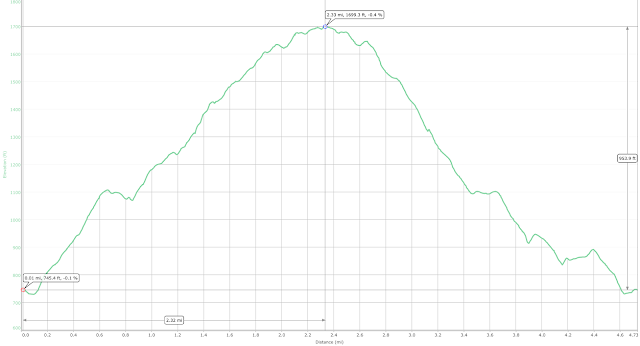
Maps, Elevations & Summary
Route to Summit: Wapack Trail (Yellow triangular blazes)Return Route: same
Distance: 3.5 miles
Maximum Elevation: 2,270 ft.
Trail Report
I arrived at the mountain at 9:00 finding only one other car in the parking lot. Last December, I attempted to reach the summit, only to be turned back by sheets of ice on the upper ledges. Today would be a lot better with temperature in the 40's and some light and intermittent showers.
The trailhead is the northern terminus of the Wapack Trail which runs all the way down to Mt. Watatic in Ashburnham, MA which by coincidence I climbed just last week. Today was to be an out-and-back to the summit following the yellow triangular blazed from the kiosk in the parking lot.
The trail starts out very level as it makes it's way to the east before gently sloping upwards. There are a number of streams and water crossings; some have wooden plank bridges, some do not.
Even with the recent rains and hard runoff, all were an easy crossing. There are some very wet sections at the bas of the mountain but all have been planked by the Friends of the Wapack crews. Thanks folks!
After an abrupt turn to the right, the trail starts upwards over a carpet of tree roots and mossy rock ledges which were very slippery in the light morning rain.
There are two 50 ft. vertical scrambles which are very easy, although I have to admit falling after slipping on a patch of wet moss. You can only really appreciate the steepness when you're in the middle of the slope.
At the top of the second scramble I bumped into a 70 year old retiree from NH and his pair of retrievers. He told me that he climbs 3 mountains a week to keep in shape.......good for him! He suggested taking the cliff trail, which adds 1/2 hour but has some beautiful views. After passing through some pine forest, I arrived at the summit with one of the biggest cairns I've seen to date.
The views from the summit are very nice, with Mount Monadnock peeking through the trees. The most unobstructed view proved to be to the north.
Through some trees, you could make out the summit of Pack Monadnock to the south with its fire and cell towers.

The Wapack trail actually heads down from the summit of North Pack to Pack Monadnock which was perhaps another 2 miles away. I'd like to try this as the weather warms up, leaving a second car at Miller State Park. Today, however, was not that day. With rain still coming down and a cold, gusty wind, I did not stay long at the summit and started back down the trail into the shelter of the pines.
On the way down, there were a couple of open meadows near smooth grating ledges that afforded a view of the Pinnacle and Crotched Mountain.
Since the rain stopped and there was some sun peaking through the clouds, it seemed like a good place for a water and snack break. In no time at all, I was back as the base of the mountain and the car.
The trailhead is the northern terminus of the Wapack Trail which runs all the way down to Mt. Watatic in Ashburnham, MA which by coincidence I climbed just last week. Today was to be an out-and-back to the summit following the yellow triangular blazed from the kiosk in the parking lot.
The trail starts out very level as it makes it's way to the east before gently sloping upwards. There are a number of streams and water crossings; some have wooden plank bridges, some do not.
Even with the recent rains and hard runoff, all were an easy crossing. There are some very wet sections at the bas of the mountain but all have been planked by the Friends of the Wapack crews. Thanks folks!
After an abrupt turn to the right, the trail starts upwards over a carpet of tree roots and mossy rock ledges which were very slippery in the light morning rain.
There are two 50 ft. vertical scrambles which are very easy, although I have to admit falling after slipping on a patch of wet moss. You can only really appreciate the steepness when you're in the middle of the slope.
At the top of the second scramble I bumped into a 70 year old retiree from NH and his pair of retrievers. He told me that he climbs 3 mountains a week to keep in shape.......good for him! He suggested taking the cliff trail, which adds 1/2 hour but has some beautiful views. After passing through some pine forest, I arrived at the summit with one of the biggest cairns I've seen to date.
The views from the summit are very nice, with Mount Monadnock peeking through the trees. The most unobstructed view proved to be to the north.
Through some trees, you could make out the summit of Pack Monadnock to the south with its fire and cell towers.

The Wapack trail actually heads down from the summit of North Pack to Pack Monadnock which was perhaps another 2 miles away. I'd like to try this as the weather warms up, leaving a second car at Miller State Park. Today, however, was not that day. With rain still coming down and a cold, gusty wind, I did not stay long at the summit and started back down the trail into the shelter of the pines.
On the way down, there were a couple of open meadows near smooth grating ledges that afforded a view of the Pinnacle and Crotched Mountain.
Since the rain stopped and there was some sun peaking through the clouds, it seemed like a good place for a water and snack break. In no time at all, I was back as the base of the mountain and the car.


